Sunday, December 18, 2016

Pitcher plants in Oregon, green but deadly


These pitcher plants that we found in the Kalmiopsis Wilderness in Oregon, are insect-eating plants. The insect crawls into the opening at the top to follow the scent to the inside of the tube, but downward-projecting hairs and a slippery surface cause the insect to be trapped inside. When it falls into the liquid inside the tube, it dies and is digested. The plant benefits from the extra nutrients. The pitcher plant tends to grow on nutrient-poor soil, so the extra nutrition gives it the chance to in places where poor soil might prevent it.

We backpacked into the Kalmiopsis Wilderness to look for and photograph the rare Kalmiopsis flower, but found many other interesting plants, too.

Remember, it's not just a picture, it's a story!

Saturday, December 17, 2016

Yosemite Falls and the Lost Arrow, Yosemite National Park


From this view along the Four Mile Trail, you can see almost all of Yosemite Falls, the Lost Arrow (to the right of the falls), the Merced River below, and parts of the trail that leads to the top of the falls. You can see that trail by basically starting at the middle of the left edge of the frame, following the line of trees that leads from the ledge up to the rounded top of granite to the left of the falls on the granite ridge.

ISO 100, f8, 1/180, 37mm focal length, taken during February, 2014.

Remember, it's not just a picture, it's a story!

Friday, December 9, 2016

Half Dome at sunset in Yosemite Valley


Sunset at Yosemite Valley with the magnificent Half Dome as the main subject. There's North Dome at the left in this view. We've posted a photo of Half Dome as seen from the top of North Dome in an earlier section of our blog. We've been to the top of Half Dome three times, and Rick has been to the top of North Dome twice. One thing about the angle that Half Dome's face has in relation to the sun is that it is very often in shadow in the morning and isn't fully lit until the afternoon. There are now people hiking to the top of Half Dome at all hours of the day. We've met people started their hike to the top of Half Dome late at night because they wanted to witness the sunrise from the top the next morning.

Camera settings were 1/125 sec. f/5.6, ISO 100, 32 mm focal length.

Remember, it's not just a picture, it's a story!

Thursday, October 27, 2016

Robinson Twins "twin selfie" in the Grand Canyon of the Yellowstone, with Lower Falls


In our August, 2015 trip, we camped at Canyon Village in Yellowstone National Park. The Grand Canyon of the Yellowstone is famous for the two waterfalls you can view from the rim of the canyon. The Lower Falls in the distance is about 300 feet high. A trail leads to the top of the falls. In this view, farther downstream, you can see much of the canyon walls, the Yellowstone River down below, some thermal features steaming from the walls, ospreys seeking fish, and the falls creating a mist.

This picture was taken with the Canon PowerShot SX530 HS at the end of a selfie stick. Rick, on the left, tried to angle the lens so that you couldn't tell that he was holding the selfie stick that easily. The previous evening, we showered at the Canyon Village's facilities and Rick bought new Yellowstone t-shirts for himself and Bob, which we were both wearing this day. Taken at ISO 100, f/8, 1/200 sec. at the widest lens angle.

Remember, it's not just a picture, it's a story!

Wednesday, October 26, 2016

Robinson Twins "twin selfie" at the Lewis River in southern Yellowstone, with Lewis Falls in the distance.


We entered Yellowstone from the south in August, 2015 and stopped at the Lewis River, where a bridge crosses over. In the distance, the highest waterfall on the river is Lewis Falls, south of Lewis Lake, from which the river drains. Lots of people stop here as essentially the first really scenic pull out along the road when coming in from the south. At least, it's the first waterfall you'll encounter when entering from the south end of the park.

Rick held his Canon PowerShot SX530 at the end of a selfie stick to take this picture. This camera is light enough that the selfie stick can hold it. This trip was the first time we decided to try getting what we call "twin selfies" with any camera. The picture was taken at ISO 200, f/8, 1/640 sec.

Remember, it's not just a picture, it's a story!

Tuesday, October 25, 2016

Yellowstone's Mammoth Hot Springs with hot water spilling over the edge of the terrace


View of Mammoth Hot Springs in Yellowstone National Park from the trail with hot water flowing from underground and spilling over the edge of a terrace that's constantly building up from the minerals, calcium carbonate, the water deposits. Steam rises from the water as it emerges from underground. The minerals form where the stream of water drips down, leaving an "icicle" of minerals. A couple of the chunks of mineral having broken off in the past and you can see the "icicles" point upward near the left-center of the screen. Another chunk is lying on its side with orange bacterial growth at the center.

This feature is in a state constant, gradual change and can engulf trees, and even parts of the terrace that are older, or the flow can shift and leave a section of the terrace dry and subject to erosion. This picture was taken with an ISO of 100, f/8, and 1/800 sec. The shutter speed helped to capture the drops of water spilling over the edge of the upper terrace.

Remember, it's not just a picture, it's a story!

Friday, October 7, 2016

Death Valley coyote looking around


Coyotes are very adaptable animals. You'll find them in the high mountains and low deserts. This one was right along the road in Death Valley National Park. It seems that after he looked at us for a while, thinking we might throw some food out for him, he started to consider his options and was looking to move on.

This photo also shows the effects of a camera lens's depth of field, where the more distant part of the scene is out of focus. Even the back and hind legs of the coyote are out of focus, but the face is in focus, which is the main thing you want to get right when you're taking wildlife photos, particularly the eye or eyes.

Remember, it's not just a picture, it's a story!

Tuesday, September 27, 2016

Manly Beacon at the upper end of Golden Canyon, Death Valley National Park, March 2016


This feature in Death Valley National Park is called Manly Beacon. An early explorer in this area was a man named Horace Manly, after whom this feature is named. It's often confused with a feature called Zabriskie Point, which is actually a hilltop from which you can view Manly Beacon, but people think they're looking "at" Zabriskie Point from that hilltop when they're actually looking "from" that hilltop.

The trail we were on for this photo eventually leads to the south side of this huge feature where you traverse across a steep slope to reach the upper end of Golden Canyon. The last few times we've hiked this trail, we've had the impression that the Beacon is a very imposing feature up close and it should be more famous as an iconic figure of Death Valley.

This photo was taken with a camcorder that can also take 20 megapixel still images. The settings were f/4, 1/180 sec, the ISO is not recorded.

Remember, it's not just a picture, it's a story!

Saturday, September 24, 2016

Acorn woodpecker in an oak tree during winter.


An acorn woodpecker stands on a branch of an oak tree in February at Phoenix Park in Sacramento County, California. This area is north of the American River beyond the bluffs. The park has baseball fields but also is home to a rare habitat, vernal pools. Vernal pools form during the winter and as they dry, several plant and animal species go through their entire life cycle to take advantage of the presence of water. For the rest of the year, the ground is dry. Acorn woodpeckers are the only woodpeckers that nest in colonies and feed on acorns.

Remember, it's not just a picture, it's a story!

Monday, September 19, 2016

The Tunnel View of Yosemite Valley


This is the famous Tunnel View of Yosemite Valley.  El Capitan, the largest granite monolith in the world, is to the left, Bridal Veil Falls and the Cathedral Rocks are on the right, and Half Dome is tucked into the back with Clouds Rest, 1,000 feet higher, beyond.  Visitors can get this view by driving up to the Wawona Tunnel and turning off at the viewpoint, or, if coming in from the south, driving through the tunnel and turning off immediately after it ends. The tunnel is about a mile long and you're expected to turn on your car's headlights while you're inside it. Don't be surprised if someone else in the tunnel starts honking their car's horn. Some drivers like to hear the echo of their horn.

Remember, it's not just a picture, it's a story.

Friday, September 16, 2016

Cathedral Rocks and Bridalveil Falls in Yosemite viewed from the north side of the Merced River


In Yosemite National Park, there are many very tall waterfalls. Bridalveil Falls is actually one of the shorter ones in Yosemite Valley. When you drive into Yosemite Valley from the south, though, it's the first one you can visit. It flows between the Cathedral Rocks to the east and the Leaning Tower to the west. Farther upstream, the Glacier Point Road crosses over Bridalveil Creek and there is a campground nearby. Bridalveil Falls gets its name because the valley gets windy, especially in the afternoon, causing the falling water to drift right and left so it comes down more like a sheet or a "veil" instead of one cohesive flow of water. The water then flows into the Merced River.

Image taken at ISO 400, 1/200 sec, f/7.1, 21 mm focal length (approximately 30 mm equivalent).

Remember, it's not just a picture, it's a story!

Monday, September 12, 2016

Grand Teton cloud eruption!


On the horizon is the towering peak of Grand Teton, as viewed from the west looking east while still in Idaho. This caught Rick's attention because of the way the clouds appeared to be coming out of the peak, as though it was a volcano spewing ash. It reminded him of pictures of volcanic eruptions, so he pulled over to the shoulder of the road to get pictures of the peak and the clouds. There is another string of cloud reaching toward the ground to the right in this image, as well. This also helps to show that the west slope of the Teton Range is gradual and leads up to the peaks, unlike the eastern, more famous side of the range that is known for not having foothills at all.

The camera is a Canon Rebel EOS xSi at f/8, 1/180 sec, ISO 200, focal length 55mm (about 86mm equivalent).

Remember, it's not just a picture, it's a story!

Friday, September 2, 2016

Telephone Arch in Telephone Canyon, Death Valley National Park


In one of Death Valley's many canyons is a natural arch. This canyon requires some driving on a dirt road to get to its mouth, then you can hike about 1/3 of a mile to see the arch. The canyon itself once had a telephone line and a road running through it, but time has obliterated most signs of them. This line gave the canyon its name of Telephone Canyon.  To us, this arch, appropriately enough, looks like an old style telephone.

The feature runs roughly north-south, so the western face is lit up during the afternoon, when this image was taken. The opening is roughly 15 feet tall (about 4.5 meters). There is a spring uphill of the arch but it appears to have dried up. The image was taken with ISO 50, 1/200 sec., f8, 6mm (35 mm equivalent).

Remember, it's not just a picture, it's a story!

Mesquite Flat Sand Dunes in Death Valley National Park wind-caused rippling pattern


Death Valley National Park has 5 different sand dunes within its borders, including California's largest in Eureka Valley. The easiest dunes to reach are the Mesquite Flats Sand Dunes because they're right next to the main road through the park. These dunes were made famous by the 1970's TV series called Kung Fu, with David Carradine.

We got up early in the morning to get to the dunes before the crowds starting traipsing across it so that we could get undisturbed ripples in the sand. The wind blowing across the sand causes some grains to collide with other grains and knocking into the next crest.

Image taken at ISO 50, 1/40 sec., f8, 8mm (48 mm equivalent).

Remember, it's not just a picture, it's a story!

Wednesday, August 31, 2016

Female Elk Walking Into the Madison River in Yellowstone National Park


This female elk had just crossed onto the opposite bank, and after a while looking around, decided to come back to the near bank. There were a couple of young elk and another female in the area hanging out while a huge crowd stood by the side of the road photographing them. Later on they decided to lie down in the tall grass and almost disappeared from view.

Taken at ISO 100, 1/250 sec, f/8, and 118 mm focal length. roughly about 660 mm (35 mm equivalent).

Remember it's not just a picture, it's a story!

Friday, August 26, 2016

Moose in the Gros Ventre River in Grand Teton National Park


A portrait of a bull moose in the Gros Ventre River in Grand Teton National Park.  This guy was actually part of a foursome of bull moose who were feasting on willow leaves along the river's edge.  Moose are the largest member of the deer family and unlike most other species of deer, they tend to be solitary and don't form herds.

Like the males of the mule deer and the elk in the park, the male moose grow antlers every spring and shed them by winter.  This is what distinguishes them from horns, since horns are permanent structures.  The antlers of the moose are different from the other members of the deer family Cervidae since they have palmate antlers meaning there are broad flattened areas of antler between the pointy tines.

Other distinguishing features of the moose is the tuft of fur at the top of the throat that hangs down called a dewlap and a pendulous snout.

Remember it's not just a picture, it's a story.


Rays of Light From the Setting Sun Create a Silver Lining in the Clouds Over the Teton Range, Wyoming


On August 10, 2016, we were in Grand Teton National Park. After spending some time photographing 4 bull moose along the Gros Ventre River, we drove north along the range and noticed that the sun was setting and creating a fringed look to the clouds. In this image, you can see the silhouette of the Teton range, parts of which still have snow. In the clouds, the lobes of the clouds were creating a light and dark pattern to the sunlight. The clouds themselves appeared to have a silver lining.

The image was taken with a Canon PowerShot SX530 HS, ISO 100, f8, 1/640 sec. zoomed at 65.4mm. Taken on August 10th, at 7:50PM from the Teton Park Road.

Remember, it's not just a picture, it's a story!

Undine Falls in northern Yellowstone National Park


Undine Falls in the north of Yellowstone National Park about four miles east of Mammoth Village.  In three separate plunges Lava Creek falls about 60 feet over a cliff of basalt lava flows.  These falls can be viewed by a short hike from the park road to an overlook.  If you look closely, you'll see a trail passing by the falls on the other side of the canyon.  During his college years, Bob hiked on that trail past Undine Falls on a backpack trip from Mammoth to the Black Canyon of the Yellowstone River east and north of these falls.

This image was shot at 1/4th of a second to create the silky appearance of the water.

Remember, it's not just a picture, it's a story.

Wednesday, August 24, 2016

Mormon barn and the Tetons


This image is from along the Antelope Flats Road in Grand Teton National Park.  It shows the historic Moulton barn of the Mormon settler era with the highest peaks of the Tetons on the horizon.

The Mormon settlers dug many ditches to supply their fields with water from the nearby Gros Ventre River, and many of these ditches still have water flowing through them.  Bob was standing right next to one of them when he took these photos.

We created this panoramic image by merging three images together.

Remember, it's not just a picture, it's a story.

Cloud stream over the Tetons


Clouds streaming over Grand Teton and other Teton peaks.  This image was taken from the Windy Point Turnout along the Teton Park Road in Grand Teton National Park, Wyoming.

We used a welder's glass held in front of the camera's lens to induce a very long shutter speed in order to give the clouds a chance to move through the frame.  Because of the welder's glass, the original image took on a strong green tint, which we corrected with photo editing software.

The f/stop was 16, exposure was 114 seconds, with the ISO at 100 and the 18-55 zoom lens set at 31mm.

Remember, it's not just a picture, it's a story!

Monday, August 22, 2016

Swan with young ones in Jackson Hole, Wyoming


Here is a recent picture of a trumpeter swan adult bird with two young ones swimming next to it. We visited Jackson Hole, Wyoming and got this picture by simply pulling off to the side of the road with lots of other people. There was even a platform on which to stand. Trumpeter swans are an endangered species that lives in Grand Teton and Yellowstone National Parks, but this one was south of either park near the town of Jackson, Wyoming, in the National Elk Refuge. whose boundary comes right up to the road.

This image was taken with the ISO at 100, f/8, 1/400 sec.

Remember, it's not just a picture, it's a story!

Saturday, August 6, 2016

The Moon rising in the Yosemite area before sunset


The nearly full moon will rise before the sun has completely set. Here's a picture in the Yosemite area taken from Yosemite Valley looking southeasterly at the rising moon with the landscape still being lit by the sun. We were in Yosemite to get moonbow pictures. Fortunately we were there early enough to get the moon rise, as well.

Camera was set at f/4 and 1/60 sec and was handheld. The ISO wasn't recorded. This image was taken using an ultra-high definition camcorder that can also take 20 megapixel stills.This was originally a 20 megapixel still image, but has been cropped and then resized for our blog.

Remember, it's not just a picture, it's a story!

Friday, August 5, 2016

Death Valley's Telescope Peak reflected in Badwater Basin on a winter day


Badwater Basin is the lowest elevation in the western hemisphere at 282 feet (86 meters) below sea level. The name comes from this year-round spring where the water comes out salty and is not good to drink. It's located in Death Valley National Park in the state of California. Only 20 miles (32km) from Badwater Basin is Telescope Peak at 11,049 feet (3368 meters) elevation. During the winter it gets covered in snow along with much of the Panamint Mountains.

The geological explanation for the low elevation is the mountain ranges on either side of Death Valley, Panamint to the west and Amargosa to the east, are tilting up and away from the valley, leading to less support for the land in between, resulting in sinking. Death Valley is technically not a valley, because, geologically, valleys form by flowing water. Death Valley formed by the land subsiding. This type of geologic feature is given a German name "graben" pronounced like the bird "robin". But no one will campaigning to the Park Service to have the name of the park changed to "Death Graben."

Remember, it's not just a picture, it's a story!

Thursday, July 28, 2016

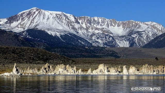
Mono Lake's tufa towers with the snowy Sierra Nevada mountains in the distance, March 2016


Mono Lake tufa towers and Sierra Nevada snowy mountains, spring 2016


This is the view from Mono Lake looking westward toward the peaks in Yosemite National Park. This image was recorded in the spring of 2016 while there was still snow on the Sierra Nevada crest and eastern face. The entire scene was well-lit by the morning sun rising in the east behind us. Rick wanted to create an image that had depth, so he included in this image the closer water, the line of tufa towers, two rolling hills at two different distances, and the higher hills before reaching the crest of the mountains. The tufa towers formed underwater when calcium-rich spring water flowed up into the lake with its carbonate-rich water. The calcium carbonate that results from the reaction of these basic components yields a solid tower. The calcium carbonate compound is the same material that makes up sea shells.

Remember, it's not just a picture, it's a story!

Monday, July 25, 2016

A Mono Lake Tufa Tower "Pinching" the Moon


On our return from a trip to Death Valley, we camped south of Mono Lake, on the east side of the Sierra. Mono Lake is famous for its tufa towers, calcium carbonate structures that formed underwater, now exposed due to Los Angeles diverting 4 of the 5 fresh water streams that flow into the salty lake causing the lake level to drop. We were up early enough to get sunrise shots and while taking pictures of the tufa towers reflected in the water, we noticed that the moon was setting. Rick positioned himself near this tower that had two peaks that appeared to have a pinching action, so it would appear that the two peaks are pinching the moon between them.

The image was taken before 8 AM on March 27th, 2016 as the sun was rising to light the tower's east face and the moon was setting in the west. The camera settings were f22, 1/30 second, and ISO 100, with the camera set on a tripod and using the timer function to allow the camera to be still.

Remember, it's not just a picture, it's a story!

Tuesday, June 21, 2016

City of Rocks National Preserve in Idaho has the Window Arch, a rare granite arch


The City of Rocks is an out-of-the-way National Preserve in south-eastern Idaho where granite spires, domes, and loaves seem to pop out of the rolling plains. Historically, this area is famous for the pioneers on the California Trail heading west and having this landmark serve as a special stop along the way. Many of the pioneers signed their names on the granite rock using axle grease. This place is also famous with climbers for some of the clean granite rock that makes for excellent climbs. We climbed one of the easier climbs in the area before taking lots of pictures. Since granite rarely forms arches, we made a point of looking for this feature, Window Arch. It's right next to a parking area for camping off of the main road through the area. Window Arch appears to be on the verge of falling down. The horizontal pieces of the arch have split and are offset from each other. It looks like either or both sides could some day soon slide past the other and collapse. Granite might form arches when sheets of granite flake off in a process called exfoliation. If both sides of a dome-shaped granite rock flake off, there may be left behind the highest part of the dome or loaf left behind, thus making an arch.

This image was made by merging two images together to increase the amount of detail in the final image. Both images taken at ISO 100, f8.0, 1/180 sec. with a Canon Rebel xSi, with a focal length of 18 mm. Rick made a point of composing this image so that the sky and top of the tree would be clear of the underside of the arch.

Remember, it's not just a picture, it's a story!

Wednesday, June 8, 2016

Mono Lake tufa tower pointing at the moon


It's all a matter of perspective! While returning to Sacramento from a trip to Death Valley, we stayed for one night in the Mono Lake area so that we could get early morning images in the Mono Lake basin. From the south shore, at what used to be the state park, we hiked out to the shore to look at the features and set up our tripods for photos of the lake and the tufa towers. Along the way, Rick noticed that the moon would be setting as the morning progressed and wanted to include it in some of his pictures. He lined up this image to include a tufa tower and the moon so that the tower appears to point to the moon. The early morning sun was lighting one side of the tower and the moon appears to be immediately above it.  In this shot, the moon appears to be the yin yang symbol.

Remember, it's not just a picture, it's a story!

Friday, May 27, 2016

Half Dome accompanied by a nearly full moon


Yosemite National Park's most famous landmark, Half Dome, accompanied by a nearly full moon in spring. On Half Dome, the small feature that protrudes from the top edge is called "The Visor." We've been to the top of Half Dome three times and each time we've heard people refer to that feature as "The Diving Board". But the "Diving Board" is a feature along the same ridge as Half Dome but is well below and not part of Half Dome. Ansel Adams took a famous photo of Half Dome from the Diving Board called "The Monolith."

To get this image, we stood in the Ahwahnee Meadow 2 nights before the actual full moon hoping to line up the eastern edge of Half Dome with the moon as it rose. A night or two before the full moon is often best for these kind of shots because the sun will still be up enough to light the scenery you want to include with the moon. Especially in a steep place like Yosemite Valley, waiting until the night of the full moon to try a get a photo that combines the landscape with a rising moon will be more difficult since the sun will have already set by the time the moon is high enough to be seen with the landscape.

Remember, it's not just a picture, it's a story!

Wednesday, May 25, 2016

A female elephant seal flips sand onto its back to stay cool, at AƱo Nuevo State Park, California


This female elephant seal was resting at AƱo Nuevo State Park, in California. Because elephant seals have so much blubber to stay warm in the cold water, they tend to overheat when they're not in the water. To keep cool, elephant seals will try to find cool spots to lie on and will flip sand onto their backs to create a little shade on their skin. 

We observed these elephant seals during a guide hike conducted by docents with the state park. During the breeding season for the elephant seals, hikers must go with a guide on an organized trip to protect the seals. Our guide had a lot of great stories to tell and photos of himself and the elephant seals when he used to do research on this species. He even had a picture of himself using an elephant seal as his pillow while he took a nap.

The elephant seal species was nearly wiped out by sealers, but their population has come back strong. One interesting aspect of their recovery is that historically they would only breed on islands, not on the mainland. Now they are hauling out on the mainland for breeding. So what prevented them from breeding on the mainland in the past? The California grizzly bear, which is now extinct due to human activity.

Remember, it's not just a picture, it's a story!
Saturday, April 23, 2016

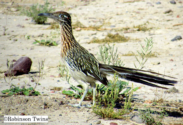
Road Runner searching for a morning meal in Death Valley

copr The Robinson Twins

While we were waiting at the entrance station for the Furnace Creek campground in Death Valley National Park, hoping to get a campsite for the night, 2 road runners came trotting by looking to have a breakfast. The first one just kept going, but the second one stopped and posed sometimes, before scurrying on. Rick managed to get this full framed image of the bird during one of his stops. Road runners eat lizards and snakes and aren't usually chased by coyotes. They are in the same bird family as cuckoos.

Remember, it's not just a picture, it's a story!

Thursday, April 21, 2016

Sagebrush Lizard, Death Valley; America's Next Top Lizard's Closeup


This is the same lizard as the previous post.  Bob had his camera set to do closeup shots of the wildflowers in bloom, so he tried to get a closeup of this lizard, since he seemed to be very cooperative about letting us take photos of him.  Bob was able to get within an inch of his face to get this shot.

Remember, it's not just a picture, it's a story.

Wednesday, April 20, 2016

"America's Next Top Lizard", a sagebrush lizard at Dante's View, Death Valley National Park


While in Death Valley during this year's "superbloom", we went to Dante's View to look down on Death Valley from a high vantage point and managed to find a photogenic lizard. This little guy stayed on the top of this rock for over half an hour. We got closer and closer to it to get pictures and it didn't seem to mind at all. Eventually, we even put on close up lenses and got pictures of its face. The lenses came to within an inch of its face, but it still didn't move. Rick started calling it "America's Next Top Lizard", because it turned out to be such a good model for us. We pointed it out to people passing by and they were able to get their smartphones close to it for close up images, too. It finally left after we saw an insect land on the rock below it and the lizard dropped down quickly to snatch the bug in its mouth, then it scampered off to the ground and continued on its way. We wished we had a camcorder running to catch that action, but we missed it. This was the same cluster of rocks where we saw the chuckwalla shown in our earlier post.

Remember, it's not just a picture, it's a story!

Tuesday, April 19, 2016

Chuckwalla lizard in a rock crevice at Dante's View, Death Valley National Park


While visiting Death Valley to enjoy their "superbloom", we saw a chuckwalla lizard out in the open, near the Dante's View parking area. Then it moved into a rock crevice when it felt threatened. Some of the other visitors thought it was a pregnant lizard, but that's just how they look normally. This species is the largest lizard in Death Valley. It stores fat in its tail and along its sides. When threatened by a predator, a chuckwalla can work itself into a flat crevice and inflate itself in order to be completely wedged into the space such that the predator has no chance at pulling it out. You can also see that it blends in very well with the rock.

Remember, it's not just a picture, it's a story!

Sunday, March 13, 2016

Yosemite's Chilnualna Falls, near Wawona, viewed from 3 miles up the trail


This is Chilnualna Falls in Yosemite National Park, but not in the world-famous valley. South of Yosemite Valley is the historic area called Wawona. From the Wawona area, you can drive past an area called Redwood Cottages and reach the trailhead that leads to Chilnualna Falls. You can't see the tallest falls along Chilnualna Creek from Wawona because there's a big granite wall in the way. You have to hike up the trail about 3 miles before you can see it from the side, as in the photo above. Another mile up the trail, and you can stand at the brink of the falls. In about 4 miles of trail you gain about 2000 feet (about 700 meters) in elevation. This picture was taken in late spring after a wetter than average winter. During late summer, the water can be a bit warmer and the flow almost stopped. It was during a trip to the falls in August that Rick saw people soaking in the pools above the falls like hot tubs. There's even a pool right at the brink, so that people soaking in the "hot tub" can look over the edge and see the 240 foot drop right next to them. Backcountry camping is allowed beyond the falls.

As the water falls over the edge, it flows down along the granite wall, but also encounters pools along the way, causing the water to eject out away from the wall. You can see that effect in this photo. We also lucked into arriving at the right time of day to see the mist of Chilnualna Falls interact with sunlight to make a rainbow.

Remember, it's not just a picture, it's a story!

Monday, February 29, 2016

Sunset silhouette of the Teton Range in Grand Teton NP


A sunset profile of the Teton Range in Grand Teton National Park. The peak named Grand Teton is the highest peak, third from the right.  The sun's rays are flaring over the southern end of the range.  The highest peak under the rays is Buck Mountain and the canyon to the right that is the low point is Avalanche Canyon. The timing worked out for this image as Bob was driving back to camp and saw the effect the peaks were having on the light from the setting sun, so he used one of the turnouts along the main road through the park.

Remember, it's not just a picture, it's a story.

Wednesday, February 24, 2016

Minerva Terrace in Yellowstone NP, at Mammoth Hot Springs


Minerva Terrace is located at Mammoth Hot Springs, at the northern end of Yellowstone National Park.  This photo was taken in the mid-1980s and these terraces have changed over time so they no longer look like this.  Over the years, shifting water flows can cause some terraces to dry out and crumble and new terraces to form elsewhere.  This view is looking northward toward the Gardiner River Canyon where storm clouds threatened rain.

 This picture, taken during a previous trip, shows the terrace engulfing trees that used to grow on this hillside and are now dead and nearly buried.

This image, taken on the same trip as the one above, shows a sign placed on the terrace by the Park Service being gradually covered over by the minerals of the hot spring.

March 1st is Yellowstone National Park's anniversary.
Happy 144th Birthday Yellowstone!

Remember, it's not just a picture, it's a story.

Friday, January 29, 2016

Indian Rock Arch, Yosemite's only granite arch, viewed from the south looking north


This photo shows Yosemite National Park's only granite arch, called Indian Rock. It's not identfied on maps or even by the signs along the trail, that this feature is an arch. It forms through the process that erodes granite features generally, exfoliation. Sheets or plates of granite peel off through the the freeze and thaw process. Arches are rarely made of granite because the exfoliation process would have to leave the arch behind as other parts of the rock peel away. Reaching Indian Rock involves hiking three miles from the Tioga Pass Road starting at Porcupine Flat. This view of the arch is from the trail to its south looking northward during the morning. We've posted another picture of this arch in our gallery looking at it from the north looking south, with Half Dome appearing underneath the arch. We've camped near and hiked to this arch more than 5 times. This photo is 2 photos that have been merged to a proportion of 2x1.

There is another granite arch in the Sierra south of Yosemite along a route known as the Sierra Vista Scenic Byway.

Remember, it's not just a picture, it's a story!

This picture shows Bob sitting by the arch on the north side.


Monday, January 18, 2016

Double-crested cormorant near Monterey, California


This double-crested cormorant was resting on rocks along the coast between Monterey and Pacific Grove, California. Cormorants are fish-eating birds that can hunt their prey in both salt and fresh water. They can be found along the coast as well as along rivers. This one seemed quite content to rest close to the walkway that follows the coast, despite the people passing by.

Cormorants' eyes work better in air than they do in water. According to a study of the greater cormorant in England, cormorants only see well enough to catch fish about 1 meter (3 feet) in front of them and their snake-like necks allow them to strike quickly at a fish that is within range. The small tooth-like structures in the bill point backwards and keep the fish from escaping after the bird bites down.

Remember, it's not just a picture, it's a story!
Friday, January 15, 2016

California's El Dorado National Forest's Bridalveil Falls, between Sacramento and Lake Tahoe


On the drive between Sacramento and Lake Tahoe, along Highway 50, in the El Dorado National Forest, there's a turnout for people to view Bridalveil Falls where Esmeralda Creek flows over the brink on its way to join the South Fork of the American River. We were on our way to the Sierra to get in a few hours of cross-country skiing while California has plenty of snow. The storm that dropped snow on the mountains was followed by a blast of cold air, so the falls had ice coating the rocks away from the main stream. Because we look like well-equipped photographers, we are often asked to take group photos for other people, and that did happen while we were stopped at these falls. The family seemed happy with the result.

This image is a merging of three images taken horizontally from top to bottom using the same settings for each. These were ISO 100, f4, 1/45 sec. It has been cropped to a 4x6 ratio and would make a good 8x12 picture.

Remember, it's not just a picture, it's a story!

Wednesday, January 13, 2016

Whimbrel shorebird searching for food at San Carlos Beach, Monterey, California


A whimbrel is a shorebird with a long decurved bill used for probing into the sand to find edible mollusks. This one was searching for food on San Carlos Beach, in Monterey, California. Some of the other whimbrels were competing for the opportunities to feed even to the point of pushing and shoving a little. When one pushed its bill into a promising hole in the sand, sometimes another rushed in to knock the other bird out of the way and get its bill onto the food instead.

These birds are constantly in motion, so the picture was taken at 1/500 of a second to help stop action. The zoom was about 25x.

Remember, it's not just a picture, it's a story!

Tuesday, January 12, 2016

Marbled Godwit foraging on Monterey Beach


A marbled godwit foraging along San Carlos Beach in Monterey, California.  This shorebird uses its long bill to probe in the sand for invertebrates to feed on. We visited the coast at Monterey after a storm had stirred up the ocean and there were many shorebirds out foraging.

Remember, it's not just a picture, it's a story.

Heermann's gull drinking fresh water on a Monterey, California beach


Heermann's gulls are distinguished by their dark red bills and dark legs. This gull was drinking fresh water that came off the streets of Monterey, California, and flowed down onto the beach. Several other birds were taking advantage of the runoff, too. This beach is San Carlos Beach, next to Monterey's Breakwater, famous among SCUBA divers in California. It's also where we went for a field trip while in college to practice diving for our certification. We had intended to dive the time we got this picture, but a storm had just passed and another was on the way, so the ocean was too stirred up for diving and getting good pictures. The lady at the dive shop described the water clarity as "pea soup", so we didn't go diving but looked for wildlife along the coast.

Remember, it's not just a picture, it's a story!

Tuesday, January 5, 2016

Pair of resting ruddy duck males on Virginia Lake, Reno, Nevada during the winter


This pair of non-breeding ruddy duck males was resting in a similar position on Virginia Lake, in Reno, Nevada. Rick was here after a storm had gone through in December, 2015 and most of the lake was frozen. Most of the ducks and geese rested on the water, but groups of geese were standing on the edge of the ice. When Rick approached the lake to take pictures, several mallard ducks came closer expecting to be fed, but moved quickly away when someone came by walking their dog.

Remember, it's not just a picture, it's a story!